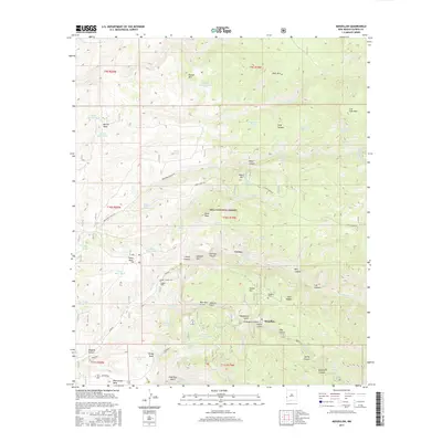
2017 Map of Mogollon
USGS Topo · Published 2017About this map
Mogollon and the nearby settlement of Cooney occupy a terrain defined by steep gulches and high mesas within the Gila National Forest. The landscape is heavily marked by its mining heritage, evidenced by the numerous named gulches such as Deadwood Gulch, Graveyard Gulch, and Coffee Gulch that surround the primary settlements. Local history and genealogy are anchored by the Mogollon Cem and the Cooney Cem, while the Cooney Tomb stands as a specific landmark near Mineral Cr. High-elevation features like Fannie Hill, Silver Peak, and Whitewater Mesa overlook a complex network of water tanks and springs, including Houston Gulch Tank and Bearup Spring, which were essential for sustaining activity in this arid, high-altitude environment. The road network, including Bursum Rd and Copper Creek Rd, navigates the difficult geography from the valley floors to the high saddles like Sled Saddle.
Find a feature on this map
75 named features on this map. Tap any name to fly to it.
Don’t see what you’re looking for? This feature index may not catch every label — zoom into the map to look around manually.
Map Details
Editions of this 2017 Mogollon Map
This is the sole edition of this map. No revisions or reprints were ever made.
Other maps of this area

1910 · Mogollon
USGS Topo · 1:125,000

1912 · Mogollon
USGS Topo · 1:125,000

1915 · Reserve
USGS Topo · 1:125,000

1918 · Reserve
USGS Topo · 1:125,000

1954 · Clifton
USGS Topo · 1:250,000

1957 · Clifton
USGS Topo · 1:250,000

1958 · Clifton
USGS Topo · 1:250,000

1962 · Clifton
USGS Topo · 1:250,000

1963 · Bearwallow Mountain
USGS Topo · 1:24,000
1963 · Sign Camp Mountain
USGS Topo · 1:24,000