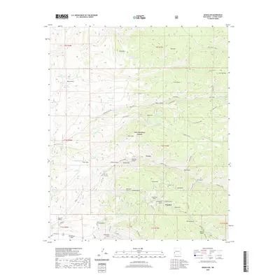
2020 Map of Mogollon
USGS Topo · Published 2020About this map
Mogollon and the nearby settlement of Cooney are the primary centers of human activity in this corner of the Gila National Forest. The landscape is dominated by a complex network of canyons and gulches, including Cooney Canyon, Graveyard Gulch, and Coffee Gulch, which suggest a history of exploration and settlement along the watercourses. The presence of the Cooney Tomb and both the Cooney Cem and Mogollon Cem offer significant touchpoints for genealogists and local historians tracking the families who inhabited these mountain drainages. The topography is defined by prominent elevations like Silver Peak and Fannie Hill, while names like Gold Dust Gulch and Needles Eye hint at the area's geological and prospecting heritage. Infrastructure is sparse, characterized primarily by routes like Bursum Rd and the Old Frisco - Devil's path winding through the high country.
Find a feature on this map
116 named features on this map. Tap any name to fly to it.
Don’t see what you’re looking for? This feature index may not catch every label — zoom into the map to look around manually.
Map Details
Editions of this 2020 Mogollon Map
This is the sole edition of this map. No revisions or reprints were ever made.
Other maps of this area

1910 · Mogollon
USGS Topo · 1:125,000

1912 · Mogollon
USGS Topo · 1:125,000

1915 · Reserve
USGS Topo · 1:125,000

1918 · Reserve
USGS Topo · 1:125,000

1954 · Clifton
USGS Topo · 1:250,000

1957 · Clifton
USGS Topo · 1:250,000

1958 · Clifton
USGS Topo · 1:250,000

1962 · Clifton
USGS Topo · 1:250,000

1963 · Bearwallow Mountain
USGS Topo · 1:24,000
1963 · Sign Camp Mountain
USGS Topo · 1:24,000