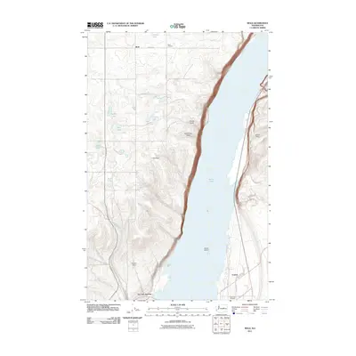
2011 Map of Mold
USGS Topo · Published 2011About this map
Banks Lake dominates the eastern half of this landscape, its waters broken only by the prominent Goose Island. The western terrain is defined by a series of smaller water bodies such as Ludike Lake, Heinlen Lake, and Tule Lake, interspersed with dramatic topographic depressions like Shrock Draw and McDonald Draw. The small settlement of Mold sits in the northern reaches, served by a network of rural roads such as Mold Rd NE and 7 1/2 Rd NE. The presence of the Mold Cemetery and the Coulee City Cemetery provides localized points for genealogical interest near the settlements of Fordair and Dry Falls Junction. This area demonstrates a characteristic high-desert landscape where modern road grids intersect with significant geological features like Pilot Rock and Purdue Draw, reflecting the agricultural and natural history of Douglas and Grant Counties.
Find a feature on this map
30 named features on this map. Tap any name to fly to it.
Don’t see what you’re looking for? This feature index may not catch every label — zoom into the map to look around manually.
Map Details
Editions of this 2011 Mold Map
This is the sole edition of this map. No revisions or reprints were ever made.
Other maps of this area

1930 · Grand Coulee Sheet 3
USGS Topo · 1:31,680

1953 · Ritzville
USGS Topo · 1:250,000

1959 · Ritzville
USGS Topo · 1:250,000

1965 · Ritzville
USGS Topo · 1:250,000

1965 · St. Andrews
USGS Topo · 1:24,000

1965 · Mold
USGS Topo · 1:24,000
1965 · Park Lake
USGS Topo · 1:24,000

1965 · Coulee City
USGS Topo · 1:24,000

1968 · Steamboat Rock SW
USGS Topo · 1:24,000

1968 · Hartline SW
USGS Topo · 1:24,000