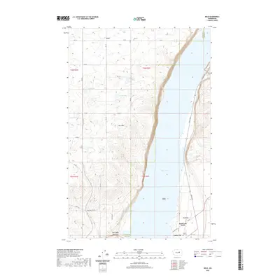
2020 Map of Mold
USGS Topo · Published 2020About this map
Banks Lake dominates the eastern half of this terrain where the high basalt plateaus of Douglas and Grant Counties meet. The landscape is defined by the stark contrast between the deep waters of the coulee and the surrounding agricultural uplands, where the small community of Mold and the Mold Cem sit among a network of rural routes like RD 9 Ne and 8 RD Ne. The mapping records a high concentration of small, ephemeral water bodies in the western plains, including Tule Lake, Sullivan Lake, and Jollys Lake, which dot the land leading toward the prominent landmark of Pilot Rock. At the southern end of the reservoir, the concentration of activity increases near Coulee City, the site of Dry Falls Junction and the Coulee City Cem. Small developments like Fordair and Banks Lake South mark the shoreline, connected by Coulee Blvd as it winds through the dramatic elevation changes of the coulee wall.
Find a feature on this map
34 named features on this map. Tap any name to fly to it.
Don’t see what you’re looking for? This feature index may not catch every label — zoom into the map to look around manually.
Map Details
Editions of this 2020 Mold Map
This is the sole edition of this map. No revisions or reprints were ever made.
Other maps of this area

1930 · Grand Coulee Sheet 3
USGS Topo · 1:31,680

1953 · Ritzville
USGS Topo · 1:250,000

1959 · Ritzville
USGS Topo · 1:250,000

1965 · Ritzville
USGS Topo · 1:250,000

1965 · St. Andrews
USGS Topo · 1:24,000

1965 · Mold
USGS Topo · 1:24,000
1965 · Park Lake
USGS Topo · 1:24,000

1965 · Coulee City
USGS Topo · 1:24,000

1968 · Steamboat Rock SW
USGS Topo · 1:24,000

1968 · Hartline SW
USGS Topo · 1:24,000