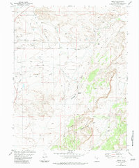
1983 Map of Molen
USGS Topo · Published 1983About this map
The settlement of Molen sits at the heart of an intricate water-management network designed to sustain life in the arid Emery County landscape. This 1983 edition illustrates the reliance on gravity-fed irrigation, featuring a complex system of channels like the Molen Ditch, Peterson Ditch, and the Dutch Flat Aqueduct. These engineering works draw from Ferron Creek to transform the Dutch Flat region. The topography is defined by sharp transitions, from the flat agricultural plains to the dramatic uplift of the Molen Reef and landmarks such as Kings Crown. Evidence of rural industry and local infrastructure is present through the Pumping Sta, a Gas Well, and the local Cem, while the presence of Molen Tanks in the southeast suggests the vital importance of water storage for livestock and ranching operations in the high desert.
Find a feature on this map
28 named features on this map. Tap any name to fly to it.
Don’t see what you’re looking for? This feature index may not catch every label — zoom into the map to look around manually.
Map Details
Editions of this 1983 Molen Map
This is the sole edition of this map. No revisions or reprints were ever made.
Other maps of this area

1885 · San Rafael
USGS Topo · 1:250,000

1885 · Manti
USGS Topo · 1:250,000

1885 · Fish Lake
USGS Topo · 1:250,000

1886 · Price River
USGS Topo · 1:250,000

1895 · Manti
USGS Topo · 1:250,000

1896 · Price River
USGS Topo · 1:250,000

1896 · Fish Lake
USGS Topo · 1:250,000

1923 · Castle Dale
USGS Topo · 1:62,500

1925 · Castle Dale
USGS Topo · 1:62,500

1952 · San Rafael Knob
USGS Topo · 1:62,500