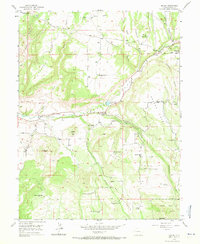
1955 Map of Molina
USGS Topo · Published 1971About this map
Molina serves as the central hub of this 1955 land study, situated where Cottonwood Creek joins the broader Plateau Valley. The landscape is a complex network of high mesas and deep drainage gulches, including Anderson Gulch and Atwell Gulch, reflecting a terrain that challenged early homesteaders. A striking number of discontinued settlements and family sites are documented here, such as the Tanner Homestead and the McKenny Homestead, indicating a period of rural consolidation or retreat by the mid-20th century.
Find a feature on this map
39 named features on this map. Tap any name to fly to it.
Don’t see what you’re looking for? This feature index may not catch every label — zoom into the map to look around manually.
Map Details
Editions of this 1955 Molina Map
5 editions found
Other maps of this area

1929 · Grand Valley
USGS Topo · 1:62,500

1955 · Collbran
USGS Topo · 1:24,000

1955 · Mesa
USGS Topo · 1:24,000

1955 · Grand Mesa
USGS Topo · 1:24,000

1955 · Molina
USGS Topo · 1:24,000

1955 · Skyway
USGS Topo · 1:24,000

1956 · Grand Junction
USGS Topo · 1:250,000

1957 · Leadville
USGS Topo · 1:250,000

1959 · Grand Junction
USGS Topo · 1:250,000

1959 · Leadville
USGS Topo · 1:250,000