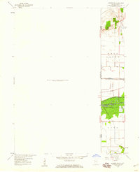
1959 Map of Momence NE
USGS Topo · Published 1960About this map
The Illinois and Indiana state line defines the eastern edge of this late 1950s landscape, where the Kankakee marshlands have been transformed into a systematic grid of agricultural drainage. Water management is the dominant feature of the terrain, illustrated by engineered waterways like Hayden Ditch and Singleton Ditch which feed into the primary Kankakee River corridor. This area reflects the mid-century intersection of industry and conservation, with the New York Central railroad cutting through the flatlands just north of the preserved acreage within Kankakee River State Park. For those tracing local heritage, the West Creek Cem sits near the northern boundary, serving as a quiet marker of the early community that established itself along the banks of West Creek.
Find a feature on this map
12 named features on this map. Tap any name to fly to it.
Don’t see what you’re looking for? This feature index may not catch every label — zoom into the map to look around manually.
Map Details
Editions of this 1959 Momence NE Map
This is the sole edition of this map. No revisions or reprints were ever made.
Other maps of this area

1922 · Momence
USGS Topo · 1:62,500

1924 · Momence
USGS Topo · 1:62,500

1949 · Crete
USGS Topo · 1:62,500

1953 · Beecher West
USGS Topo · 1:24,000

1953 · Beecher East
USGS Topo · 1:24,000

1953 · Lowell
USGS Topo · 1:24,000

1953 · Chicago
USGS Topo · 1:250,000

1957 · Chicago
USGS Topo · 1:250,000

1959 · Schneider
USGS Topo · 1:24,000
1962 · Enos
USGS Topo · 1:24,000