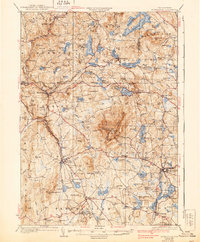
1936 Map of Monadnock
USGS Topo · Published 1939About this map
Monadnock Mtn dominates this Southwest New Hampshire landscape, a focal point for a complex network of hiking paths including the White Arrow Trail and Pumpelly Trail. The terrain is characterized by high peaks and an abundance of water bodies, from the sprawling Nubanusit Lake in the north to the cluster of ponds near Jaffrey. This 1932 survey, compiled in part from Air Corps aerial photographs, shows a region defined by its topography and the Boston and Maine railroad, which connects industrial and residential hubs like East Jaffrey and Troy.
Find a feature on this map
145 named features on this map. Tap any name to fly to it.
Don’t see what you’re looking for? This feature index may not catch every label — zoom into the map to look around manually.
Map Details
Editions of this 1936 Monadnock Map
4 editions found

Other maps of this area

1887 · Warwick
USGS Topo · 1:62,500

1887 · Winchendon
USGS Topo · 1:62,500

1887 · Fitchburg
USGS Topo · 1:62,500

1889 · Fitchburg
USGS Topo · 1:62,500

1889 · Warwick
USGS Topo · 1:62,500

1890 · Winchendon
USGS Topo · 1:62,500

1893 · Fitchburg
USGS Topo · 1:62,500

1894 · Winchendon
USGS Topo · 1:62,500

1894 · Warwick
USGS Topo · 1:62,500

1898 · Monadnock
USGS Topo · 1:62,500