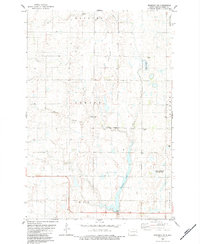
1982 Map of Monango SW
USGS Topo · Published 1983About this map
The Elm River meanders southward through the prairie of Dickey County, forming the primary drainage for this agricultural landscape. In the early 1980s, the area's social and community life centered around the Townhall, Christ Ch, and an adjacent Cem, marking a traditional rural gathering point. The terrain is defined by the shallow basin of Pheasant Lake, which features a Public Access Point for recreation. Conservation efforts are evident in the sprawling National Waterfowl Production Area, established to protect the vital wetlands of the Central Flyway. Industrial activity is localized at the Elden Gravel Pit, while the natural topography is broken by Bristol Gulch to the west. This map provides a detailed view of the township divisions between Hamburg, Albion, and Elm, showing the section lines and farmstead placements of the era.
Find a feature on this map
16 named features on this map. Tap any name to fly to it.
Don’t see what you’re looking for? This feature index may not catch every label — zoom into the map to look around manually.
Map Details
Editions of this 1982 Monango SW Map
This is the sole edition of this map. No revisions or reprints were ever made.
Other maps of this area

1894 · Monango
USGS Topo · 1:62,500

1894 · Ellendale
USGS Topo · 1:62,500

1896 · Edgeley
USGS Topo · 1:125,000

1899 · Ellendale
USGS Topo · 1:125,000

1925 · Edgeley
USGS Topo · 1:125,000

1953 · Jamestown
USGS Topo · 1:250,000

1953 · Ellendale South
USGS Topo · 1:24,000

1954 · Aberdeen
USGS Topo · 1:250,000

1956 · Aberdeen
USGS Topo · 1:250,000

1956 · Jamestown
USGS Topo · 1:250,000