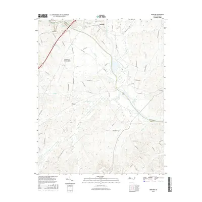
2016 Map of Moncure
USGS Topo · Published 2016About this map
Deep River and the Cape Fear River converge near the historic settlement of Moncure, creating a landscape defined by significant water systems and the infrastructure supporting them. The area shows a transition between traditional river-centered communities like Haywood and modern developments such as the Raleigh Executive Jetport at Sanford-Lee County Airport. The CSX Transportation railroad line tracks through the northern section, a reminder of the region's long-standing connection to commerce and transportation that bypassed older water-based routes. Smaller hamlets like Rosser, Blacknel, and Brickhaven are connected by a network of rural roads such as Poplar Springs Church Rd and Moncure Flatwood Rd. Numerous creeks, including Lick Creek and Bush Cr, drain the varied topography, while landmarks like Ramsey Mill Pond and McKay Island offer specific points of interest for local history researchers.
Find a feature on this map
73 named features on this map. Tap any name to fly to it.
Don’t see what you’re looking for? This feature index may not catch every label — zoom into the map to look around manually.
Map Details
Editions of this 2016 Moncure Map
This is the sole edition of this map. No revisions or reprints were ever made.
Other maps of this area

1953 · Raleigh
USGS Topo · 1:250,000

1954 · Raleigh
USGS Topo · 1:250,000

1969 · New Hope Dam
USGS Topo · 1:24,000

1970 · Pittsboro
USGS Topo · 1:24,000

1970 · Colon
USGS Topo · 1:24,000

1970 · Moncure
USGS Topo · 1:24,000
1974 · New Hill
USGS Topo · 1:24,000

1974 · Mamers
USGS Topo · 1:24,000
1974 · Cokesbury
USGS Topo · 1:24,000

1974 · Sanford
USGS Topo · 1:24,000