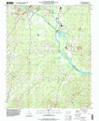
1993 Map of Moncure
USGS Topo · Published 1999About this map
The confluence of the Deep River and Haw River forms the headwaters of the Cape Fear River at the heart of this landscape, marking a historic transition point for North Carolina river navigation. Near the northern bank, the settlement of Moncure serves as a focal point alongside Haywood, while industrial activity is evident at the Powerplant and nearby Brickhaven, where a Claypit signifies the local extraction economy. The terrain is defined by a dense network of tributaries including Shaddox Creek and Lick Creek that carve through the countryside.
Find a feature on this map
41 named features on this map. Tap any name to fly to it.
Don’t see what you’re looking for? This feature index may not catch every label — zoom into the map to look around manually.
Map Details
Editions of this 1993 Moncure Map
This is the sole edition of this map. No revisions or reprints were ever made.
Other maps of this area

1953 · Raleigh
USGS Topo · 1:250,000

1954 · Raleigh
USGS Topo · 1:250,000

1969 · New Hope Dam
USGS Topo · 1:24,000

1970 · Pittsboro
USGS Topo · 1:24,000

1970 · Colon
USGS Topo · 1:24,000

1970 · Moncure
USGS Topo · 1:24,000
1974 · New Hill
USGS Topo · 1:24,000

1974 · Mamers
USGS Topo · 1:24,000
1974 · Cokesbury
USGS Topo · 1:24,000

1974 · Sanford
USGS Topo · 1:24,000