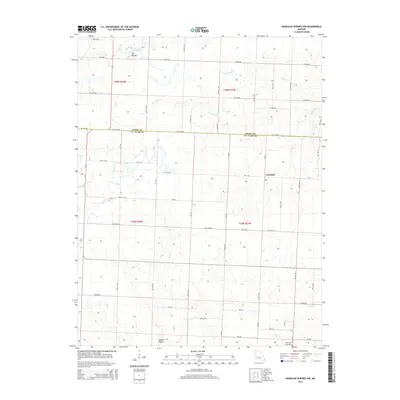
2014 Map of Monegaw Springs NW
USGS Topo · Published 2014About this map
Copeland sits at a crossroads in the central-eastern portion of this landscape, marking the transition between the rolling hills of Henry and St. Clair counties. The boundary between Henry Co St. Clair Co bisects the terrain, which is defined by a dendritic network of small waterways including Ricky Cr, Marshall Cr, and Trap Br. To the south, Golden Ridge provides a distinct geographical point of reference near the headwaters of Ditty Cr. A prominent elevation known as The Mound rises in the northwest corner near Bear Cr, suggesting the diverse topography that challenged early surveyors. This 2014 edition documents the rural layout of the region, anchored by the Harmony Cemetery in the southeast and a persistent grid of country roads such as Mo-Aa and NW 1000 Rd.
Find a feature on this map
32 named features on this map. Tap any name to fly to it.
Don’t see what you’re looking for? This feature index may not catch every label — zoom into the map to look around manually.
Map Details
Editions of this 2014 Monegaw Springs NW Map
This is the sole edition of this map. No revisions or reprints were ever made.
Other maps of this area

1887 · Clinton
USGS Topo · 1:125,000

1887 · Butler
USGS Topo · 1:125,000

1894 · Butler
USGS Topo · 1:125,000

1894 · Clinton
USGS Topo · 1:125,000

1934 · Rockville
USGS Topo · 1:24,000

1938 · Monegaw Springs
USGS Topo · 1:24,000

1938 · Taberville
USGS Topo · 1:24,000

1940 · Taberville
USGS Topo · 1:24,000
1940 · Monegaw Springs
USGS Topo · 1:24,000

1947 · Jefferson City
USGS Topo · 1:250,000