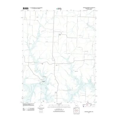
2011 Map of Monegaw Springs
USGS Topo · Published 2011About this map
Monegaw Springs sits along the northern banks of the Osage River, a historic focal point in St. Clair County defined by its natural water features and rugged local topology. The confluence of Monegaw Creek and the river creates a complex wetland environment, punctuated by named elevations like Clubhouse Hill and Youngers Lookout. This 2011 survey reveals a landscape deeply connected to its past through a high density of family and community burial grounds, including the Terry Cemetery, Parks Cemetery, and Benton Green Cemetery, which are scattered throughout the rural sections surrounding the settlement of Chalk Level. The map also details the riparian corridor where Yellow Creek and Silver Creek feed into the river system, alongside modern additions like the Wixted Airport and the recreational waters of Spring Lake.
Find a feature on this map
64 named features on this map. Tap any name to fly to it.
Don’t see what you’re looking for? This feature index may not catch every label — zoom into the map to look around manually.
Map Details
Editions of this 2011 Monegaw Springs Map
This is the sole edition of this map. No revisions or reprints were ever made.
Other maps of this area

1886 · Stockton
USGS Topo · 1:125,000

1887 · Clinton
USGS Topo · 1:125,000

1894 · Clinton
USGS Topo · 1:125,000

1937 · Tiffin
USGS Topo · 1:31,680

1938 · Monegaw Springs
USGS Topo · 1:24,000

1938 · Roscoe
USGS Topo · 1:24,000

1938 · Vista
USGS Topo · 1:24,000

1938 · Taberville
USGS Topo · 1:24,000

1939 · Osceola
USGS Topo · 1:24,000

1940 · Taberville
USGS Topo · 1:24,000