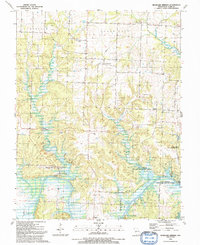
1991 Map of Monegaw Springs
USGS Topo · Published 1991About this map
Monegaw Springs and the village of Chalk Level anchor this landscape along the winding course of the Osage River during the late 20th century. The area is characterized by a high concentration of family cemeteries and rural parishes, including Motley Cem, Benton Green Cem, and Kidds Chapel, reflecting deep-seated ancestral roots in St. Clair County. The topography is defined by notable elevations such as Kibbe Hill and Youngers Lookout, which overlook the complex hydrology of Little Monegaw Creek and Gallinipper Creek. Extensive conservation efforts are evident in the sprawling Sac Osage State Wildlife Area and Salt Creek State Wildlife Area, which dominate the river valley. Traces of local infrastructure, from a prominent Pipeline to the various sections of Roscoe and Center, illustrate the blend of agrarian tradition and modern land management in this Missouri riverine environment.
Find a feature on this map
39 named features on this map. Tap any name to fly to it.
Don’t see what you’re looking for? This feature index may not catch every label — zoom into the map to look around manually.
Map Details
Editions of this 1991 Monegaw Springs Map
This is the sole edition of this map. No revisions or reprints were ever made.
Other maps of this area

1886 · Stockton
USGS Topo · 1:125,000

1887 · Clinton
USGS Topo · 1:125,000

1894 · Clinton
USGS Topo · 1:125,000

1937 · Tiffin
USGS Topo · 1:31,680

1938 · Monegaw Springs
USGS Topo · 1:24,000

1938 · Roscoe
USGS Topo · 1:24,000

1938 · Vista
USGS Topo · 1:24,000

1938 · Taberville
USGS Topo · 1:24,000

1939 · Osceola
USGS Topo · 1:24,000

1940 · Taberville
USGS Topo · 1:24,000