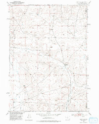
1952 Map of Moneta SE
USGS Topo · Published 1974About this map
Meigh Ranch stands as a primary landmark in this high-plains landscape of the central Wyoming basin, mapped just as the mid-century development of the Missouri River Basin project was underway. The area is defined by its sparse pastoral infrastructure, where livestock operations rely on isolated water sources like the marked Windmill and the seasonal flows of Deer Creek and Canyon Creek. To the west, the prominent geological formation known as Black Rocks breaks the high-desert horizon, providing a natural orientation point for ranchers and travelers moving through this remote boundary region between Fremont and Natrona counties. Other small-scale human imprints include the Herder site and several geodetic survey markers such as Vabm 5962, documenting the precision work of the Geological Survey during its 1952 field check.
Find a feature on this map
9 named features on this map. Tap any name to fly to it.
Don’t see what you’re looking for? This feature index may not catch every label — zoom into the map to look around manually.
Map Details
Editions of this 1952 Moneta SE Map
2 editions found
Other maps of this area

1952 · Seventy-one Reservoir
USGS Topo · 1:24,000

1952 · Moneta
USGS Topo · 1:24,000

1952 · Arminto SW
USGS Topo · 1:24,000

1952 · Love Ranch
USGS Topo · 1:24,000

1952 · Madden
USGS Topo · 1:24,000

1952 · Arminto NW
USGS Topo · 1:24,000

1952 · Moneta SE
USGS Topo · 1:24,000

1952 · Miles Ranch
USGS Topo · 1:24,000

1952 · Ervay Basin
USGS Topo · 1:24,000

1955 · Arminto
USGS Topo · 1:250,000