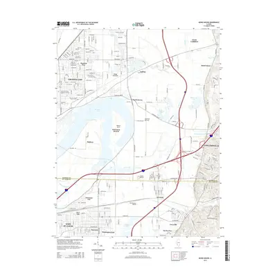
2015 Map of Monks Mound
USGS Topo · Published 2015About this map
Monks Mound and Rattlesnake Mound anchor the center of this landscape, standing as prominent archaeological landmarks within the American Bottoms. This modern survey illustrates the dense intersection of transit and topography between Granite City and Collinsville. The hydrological complexity of the region is evident in the sprawling Horseshoe Lake and the engineered routes of the Cahokia Canal and Cahokia Cr, which manage the floodplains of the Mississippi River basin. Smaller residential pockets like Maryland Place and Moellenbrocks are interspersed with industrial and educational hubs such as Sanford-Brown College. For genealogists, the map preserves the locations of local burial grounds, including the Saint Johns United Church of Christ Old Cem and Kirkpatrick Cem, providing precise coordinates for family history research in this long-inhabited valley.
Find a feature on this map
101 named features on this map. Tap any name to fly to it.
Don’t see what you’re looking for? This feature index may not catch every label — zoom into the map to look around manually.
Map Details
Editions of this 2015 Monks Mound Map
This is the sole edition of this map. No revisions or reprints were ever made.
Other maps of this area

1888 · St. Louis
USGS Topo · 1:62,500

1907 · Belleville
USGS Topo · 1:62,500

1927 · Alton
USGS Topo · 1:62,500

1927 · Edwardsville
USGS Topo · 1:62,500

1931 · French Village
USGS Topo · 1:24,000

1932 · Edwardsville
USGS Topo · 1:62,500

1933 · Granite City
USGS Topo · 1:24,000

1933 · Cahokia
USGS Topo · 1:24,000

1934 · Cahokia
USGS Topo · 1:24,000

1934 · Alton
USGS Topo · 1:62,500