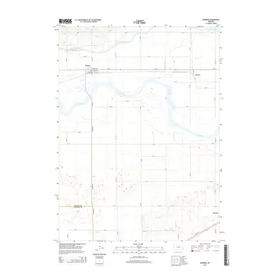
2014 Map of Monroe
USGS Topo · Published 2014About this map
The Loup River and its parallel human-made counterpart, the Loup River Canal, dominate this section of the Platte Valley. This 2014 survey documents the agricultural and hydrological layout of the region, where the town of Monroe serves as a local hub near the intersection of Columbus Ave and Railroad Ave. The landscape is a study in precision irrigation and drainage, evidenced by the long straight reaches of the Lost Cr Ditch and the regulated flow of the canal system north of the river. To the east, the small settlement of Oconee sits near the banks of the Lost Cr, while Duncan is situated in the southeastern corner at the border of Platte Co and Merrick Co. The map reveals a highly structured grid of section roads, including Monroe Rd and 340 Ave, which facilitate the intensive farming operations characteristic of this Nebraska corridor.
Find a feature on this map
39 named features on this map. Tap any name to fly to it.
Don’t see what you’re looking for? This feature index may not catch every label — zoom into the map to look around manually.
Map Details
Editions of this 2014 Monroe Map
This is the sole edition of this map. No revisions or reprints were ever made.
Other maps of this area

1896 · Stromsburg
USGS Topo · 1:125,000

1899 · David City
USGS Topo · 1:125,000

1955 · Fremont
USGS Topo · 1:250,000

1957 · Fremont
USGS Topo · 1:250,000

1958 · Fremont
USGS Topo · 1:250,000

1958 · Genoa
USGS Topo · 1:24,000

1958 · Monroe
USGS Topo · 1:24,000

1958 · Duncan
USGS Topo · 1:24,000

1958 · Columbus SW
USGS Topo · 1:24,000

1958 · Silver Creek SE
USGS Topo · 1:24,000