
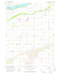
1958 Map of Columbus SW
USGS Topo · Published 1959About this map
The confluence of the Platte River and its intricate drainage systems defines this part of the Nebraska landscape in the late 1950s. The survey illustrates the complex hydrology of the South Channel Clear Creek and the main branch of Clear Creek, which carve through the townships of Butler and Polk County. This era of rural development is marked by a systematic network of local education, evidenced by the distribution of one-room schoolhouses like School No 16 and School No 18 across the agricultural grid. The southern portion of the map transitions into the distinctive terrain of Canada and Clear Creek, where the land rises sharply from the river valley. Community life is anchored by landmarks such as St Andrews Ch, while the local economy is reflected in industrial sites like the Gravel Pit near the island flats.
Find a feature on this map
14 named features on this map. Tap any name to fly to it.
Don’t see what you’re looking for? This feature index may not catch every label — zoom into the map to look around manually.
Map Details
Editions of this 1958 Columbus SW Map
2 editions found
Other maps of this area

1896 · Stromsburg
USGS Topo · 1:125,000

1899 · David City
USGS Topo · 1:125,000

1955 · Fremont
USGS Topo · 1:250,000

1957 · Fremont
USGS Topo · 1:250,000

1958 · Fremont
USGS Topo · 1:250,000

1958 · Monroe
USGS Topo · 1:24,000

1958 · Duncan
USGS Topo · 1:24,000

1958 · Silver Creek SE
USGS Topo · 1:24,000

1958 · Columbus SE
USGS Topo · 1:24,000

1958 · Columbus
USGS Topo · 1:24,000