
1963 Map of Mont Clare
USGS Topo · Published 1964About this map
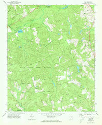
The Pee Dee River carves a winding path along the boundary of Darlington and Marlboro counties, defining a landscape of agricultural fields and dense swampy bottomlands in the early 1960s. Central to this survey is the community of Mont Clare, located near the intersection of the Atlantic Coast Line railroad and local rural routes. Genealogists will find a wealth of named landmarks and family-associated locations, including the Governor Williams Cem near Robbins Neck and the Gandy Cem near the settlement of Gandy.
Find a feature on this map
32 named features on this map. Tap any name to fly to it.
Don’t see what you’re looking for? This feature index may not catch every label — zoom into the map to look around manually.
Map Details
Editions of this 1963 Mont Clare Map
This is the sole edition of this map. No revisions or reprints were ever made.
Other maps of this area

1942 · Rockingham
USGS Topo · 1:125,000

1943 · Gum Swamp
USGS Topo · 1:62,500

1953 · Florence
USGS Topo · 1:250,000

1954 · Florence
USGS Topo · 1:250,000

1963 · Dovesville
USGS Topo · 1:24,000

1963 · Darlington East
USGS Topo · 1:24,000

1963 · Darlington West
USGS Topo · 1:24,000

1971 · Society Hill
USGS Topo · 1:24,000
1972 · Cash
USGS Topo · 1:24,000

1972 · Drake
USGS Topo · 1:24,000