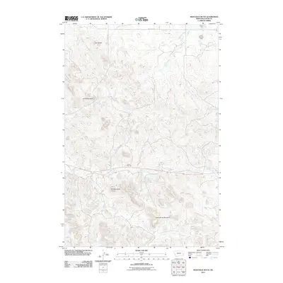
2011 Map of Montague Butte
USGS Topo · Published 2011About this map
Montague Butte and Henry Woods Mountain define the high ground of this Custer County landscape, where the drainage systems of the eastern Montana plains intersect. The map illustrates a complex network of seasonal and perennial waterways including Locate Creek, Whitney Creek, and the North Fork Locate Creek, which carve through the terrain between prominent landmarks like Rattlesnake Butte and Twin Buttes. Human infrastructure is sparse but notable, centered around water management and transportation. The presence of Smith Dam and the Leland Number 1 Dam in the northeast corner suggests the critical role of water storage for local ranching or agricultural needs. Transportation is limited to functional routes like the Terry Cut Across Rd and Whitney Cr Rd, with the Locate Rest Area serving as a modern waypoint along the central corridor.
Find a feature on this map
17 named features on this map. Tap any name to fly to it.
Don’t see what you’re looking for? This feature index may not catch every label — zoom into the map to look around manually.
Map Details
Editions of this 2011 Montague Butte Map
This is the sole edition of this map. No revisions or reprints were ever made.
Other maps of this area

1953 · Miles City
USGS Topo · 1:250,000

1957 · Miles City
USGS Topo · 1:250,000

1958 · Miles City
USGS Topo · 1:250,000

1969 · Little Whitney Creek
USGS Topo · 1:24,000

1969 · Knowlton
USGS Topo · 1:24,000

1969 · Hogan Creek
USGS Topo · 1:24,000

1969 · Montague Butte
USGS Topo · 1:24,000

1969 · Flat Top Butte SW
USGS Topo · 1:24,000
1969 · Red Knob
USGS Topo · 1:24,000

1980 · Terry
USGS Topo · 1:100,000