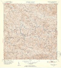
1952 Map of Monte Guilarte
USGS Topo · Published 1953About this map
The Cordillera Central dominates this 1952 topographic study, revealing a dense network of coffee-era estates and highland settlements across the municipalities of Adjuntas, Lares, and Yauco. The landscape is defined by its numerous haciendas, including Hacienda Monserrate, Hacienda Indiera, and Hacienda Santa Maria, which underscore the agricultural importance of these mountain slopes. In the vicinity of Yahueca, institutional landmarks like the Escuela Segunda Unidad de Yahueca and Iglesia de la Virgen del Carmen serve as community anchors.
Find a feature on this map
134 named features on this map. Tap any name to fly to it.
Don’t see what you’re looking for? This feature index may not catch every label — zoom into the map to look around manually.
Map Details
Editions of this 1952 Monte Guilarte Map
2 editions found
Other maps of this area

1937 · Sabana Grande
USGS Topo · 1:25,000

1938 · San Sebastian
USGS Topo · 1:20,000

1941 · San Sebastian
USGS Topo · 1:30,000

1941 · Sabana Grande
USGS Topo · 1:30,000

1946 · Maricao
USGS Topo · 1:30,000

1946 · Utuado
USGS Topo · 1:30,000

1946 · Bayaney
USGS Topo · 1:30,000

1946 · Yauco
USGS Topo · 1:30,000

1946 · Monte Guilarte
USGS Topo · 1:30,000

1946 · Penuelas
USGS Topo · 1:30,000
Featured Places
- Sector Lombrices, Adjuntas
- Sector Los Pagán, Adjuntas
- Sector Palo Seco, Adjuntas
- Sector Jiménez Santiago, Adjuntas
- Sector Titulo Quinto, Adjuntas