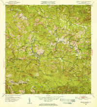
1952 Map of Monte Guilarte
USGS Topo · Published 1953About this map
The Cordillera Central mountain range dominates this 1952 topographic study, showcasing the dense agricultural and religious infrastructure of the Adjuntas and Lares regions. The landscape is defined by an extensive network of family-named estates such as Hacienda Monserrate, Hacienda Maria Carolina, and Hacienda Santa Maria, reflecting the era's coffee and tobacco farming heritage. The map documents vital social centers including the Hospital General de Castaner and various religious sites like the Iglesia de la Virgen del Carmen and Iglesia Protestante. Transportation is anchored by the winding paths of PR 128 and PR 135, which navigate the complex drainage systems of the Rio Guayo and Rio Blanco. This mid-century survey captures a period of active rural life where local schools like Escuela Segunda Unidad de Yahueca served scattered mountain communities.
Find a feature on this map
127 named features on this map. Tap any name to fly to it.
Don’t see what you’re looking for? This feature index may not catch every label — zoom into the map to look around manually.
Map Details
Editions of this 1952 Monte Guilarte Map
2 editions found
Other maps of this area

1937 · Sabana Grande
USGS Topo · 1:25,000

1938 · San Sebastian
USGS Topo · 1:20,000

1941 · San Sebastian
USGS Topo · 1:30,000

1941 · Sabana Grande
USGS Topo · 1:30,000

1946 · Maricao
USGS Topo · 1:30,000

1946 · Utuado
USGS Topo · 1:30,000

1946 · Bayaney
USGS Topo · 1:30,000

1946 · Yauco
USGS Topo · 1:30,000

1946 · Monte Guilarte
USGS Topo · 1:30,000

1946 · Penuelas
USGS Topo · 1:30,000
Featured Places
- Sector Los Pagán, Adjuntas
- Sector Palo Seco, Adjuntas
- Sector Jiménez Santiago, Adjuntas
- Sector Titulo Quinto, Adjuntas
- Sector Lombrices, Adjuntas