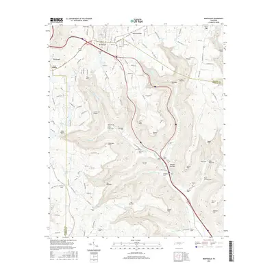
2016 Map of Monteagle
USGS Topo · Published 2016About this map
Monteagle sits atop the southern Cumberland Plateau, where the modern interstate corridor follows the historic path of the Dixie Lee Hwy. This 2016 survey documents the complex topography of the Grundy and Marion County border, characterized by deep coves and prominent sandstone points. To the east, Tracy City and Summerfield anchor the plateau, while the land drops sharply into massive depressions like Gizzard Cove and Monteagle Cove. The map traces a long history of settlement through numerous small family and community burial grounds, including the White Cem, Saint Johns Cem, and Hargiss Cem. Water plays a central role in the landscape's character, with significant features such as Bridal Veil Falls, Jumpoff Falls, and Tom McBee Lake scattered throughout the drainage basins of Trussell Cr and Battle Creek.
Find a feature on this map
139 named features on this map. Tap any name to fly to it.
Don’t see what you’re looking for? This feature index may not catch every label — zoom into the map to look around manually.
Map Details
Editions of this 2016 Monteagle Map
This is the sole edition of this map. No revisions or reprints were ever made.
Other maps of this area

1895 · Sewanee
USGS Topo · 1:125,000

1936 · Sewanee
USGS Topo · 1:24,000

1936 · Alto
USGS Topo · 1:24,000

1936 · Orme
USGS Topo · 1:24,000

1936 · Sinking Cove
USGS Topo · 1:24,000

1936 · Burrow Cove
USGS Topo · 1:24,000

1936 · Tracy City
USGS Topo · 1:24,000

1936 · Monteagle
USGS Topo · 1:24,000

1936 · White City
USGS Topo · 1:24,000
1936 · South Pittsburg
USGS Topo · 1:24,000