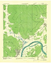
1936 Map of South Pittsburg
USGS Topo · Published 1936About this map
The Proposed Guntersville Reservoir looms over this 1936 landscape, a transitional moment captured before the Tennessee River was transformed by the Tennessee Valley Authority. At the foot of the Cumberland Plateau, the industrial and residential grid of South Pittsburg sits near the South Pittsburg Ferry, while the neighboring town of Jasper is depicted in its pre-war layout. The map documents a dense network of rural infrastructure, including the Nashville Chattanooga And ST Louis Railroad and the CCC Camp No 38 in Pryor Cove. Local history is preserved through numerous family and community landmarks, such as Ebenezer Ch, the Gilliam Cem, and several schoolhouses like the Battle Creek Institute. Abandoned mines and a Quarry near Richard City hint at the region's extraction-based economy during the mid-1930s.
Find a feature on this map
61 named features on this map. Tap any name to fly to it.
Don’t see what you’re looking for? This feature index may not catch every label — zoom into the map to look around manually.
Map Details
Editions of this 1936 South Pittsburg Map
This is the sole edition of this map. No revisions or reprints were ever made.
Other maps of this area

1886 · Stevenson
USGS Topo · 1:125,000

1892 · Stevenson
USGS Topo · 1:125,000

1895 · Stevenson
USGS Topo · 1:125,000

1895 · Sewanee
USGS Topo · 1:125,000

1936 · Shellmound
USGS Topo · 1:24,000

1936 · Orme
USGS Topo · 1:24,000

1936 · Bridgeport
USGS Topo · 1:24,000

1936 · Whitwell
USGS Topo · 1:24,000

1936 · Monteagle
USGS Topo · 1:24,000

1936 · White City
USGS Topo · 1:24,000