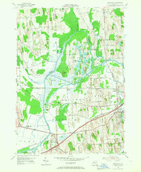
1954 Map of Montezuma
USGS Topo · Published 1967About this map
Howland Island Game Refuge sits at the heart of this mid-century landscape, defined by the winding course of the Seneca River and its intricate network of island formations. The map documents a critical hydrologic and transit corridor in Cayuga County, where the historic Erie Canal and the Old Erie Thruway parallel one another. To the south, the Montezuma National Wildlife Refuge marks a significant conservation area at the confluence of the river and the Owasco Lake Outlet. The settlement patterns around Port Byron and North Port Byron reflect the region's deep ties to canal and rail transport, with the New York Central railroad cutting a straight line across the marshlands. Small rural hubs like Cottage Corners and Montezuma Station remain visible, providing essential points of reference for genealogists studying the families settled along roads like Yellow Schoolhouse Road and Drabble Road.
Find a feature on this map
54 named features on this map. Tap any name to fly to it.
Don’t see what you’re looking for? This feature index may not catch every label — zoom into the map to look around manually.
Map Details
Editions of this 1954 Montezuma Map
Other maps of this area

1899 · Auburn
USGS Topo · 1:62,500

1902 · Geneva
USGS Topo · 1:62,500

1902 · Clyde
USGS Topo · 1:62,500

1902 · Weedsport
USGS Topo · 1:62,500

1902 · Auburn
USGS Topo · 1:62,500

1943 · Montezuma
USGS Topo · 1:31,680

1943 · Cayuga
USGS Topo · 1:31,680

1943 · Cato
USGS Topo · 1:31,680

1943 · Savannah
USGS Topo · 1:31,680

1943 · Weedsport
USGS Topo · 1:31,680