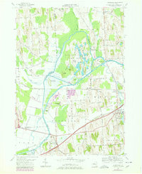
1954 Map of Montezuma
USGS Topo · Published 1978About this map
The Seneca River and the historic Erie Canal dominate this landscape at the intersection of Wayne, Cayuga, and Seneca counties. The area is defined by its extensive marshlands and water management, anchored by the Howland Island Game Refuge and the Montezuma National Wildlife Refuge. Settlement patterns follow the higher ground and transportation corridors, with Port Byron serving as a primary hub where the Owasco Lake Outlet meets the canal system. Smaller communities and rural crossroads like Conquest, Fox Ridge, and Willow Grove are connected by a network of named tracks such as Yellow Schoolhouse Road. The map documents the mid-century infrastructure of the region, including the Erie Thruway and several critical crossings like High Bridge and Free Bridge that navigate the complex waterways of the marsh.
Find a feature on this map
58 named features on this map. Tap any name to fly to it.
Don’t see what you’re looking for? This feature index may not catch every label — zoom into the map to look around manually.
Map Details
Editions of this 1954 Montezuma Map
Other maps of this area

1899 · Auburn
USGS Topo · 1:62,500

1902 · Geneva
USGS Topo · 1:62,500

1902 · Clyde
USGS Topo · 1:62,500

1902 · Weedsport
USGS Topo · 1:62,500

1902 · Auburn
USGS Topo · 1:62,500

1943 · Montezuma
USGS Topo · 1:31,680

1943 · Cayuga
USGS Topo · 1:31,680

1943 · Cato
USGS Topo · 1:31,680

1943 · Savannah
USGS Topo · 1:31,680

1943 · Weedsport
USGS Topo · 1:31,680