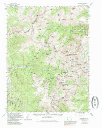
1974 Map of Montezuma
USGS Topo · Published 1985About this map
High alpine mining camps and high-altitude passes define this rugged section of the Continental Divide during the mid-20th century. The remote settlement of Montezuma sits at the heart of a dense network of silver and lead claims, surrounded by historic sites like Saints John, Swandyke, and Graymont. The industrial footprint is extensive, with dozens of named excavations including the Seven-Thirty Mine, Pennsylvania Mine, and the Radical Mines scattered across the steep drainages of the Snake River and Clear Creek.
Find a feature on this map
158 named features on this map. Tap any name to fly to it.
Don’t see what you’re looking for? This feature index may not catch every label — zoom into the map to look around manually.
Map Details
Editions of this 1974 Montezuma Map
This is the sole edition of this map. No revisions or reprints were ever made.
Other maps of this area

1889 · Leadville
USGS Topo · 1:125,000

1891 · Leadville
USGS Topo · 1:125,000

1903 · Georgetown
USGS Topo · 1:62,500

1905 · Central City
USGS Topo · 1:62,500

1905 · Georgetown
USGS Topo · 1:62,500

1910 · Central City
USGS Topo · 1:62,500

1912 · Central City
USGS Topo · 1:62,500

1924 · Montezuma
USGS Topo · 1:62,500

1924 · Fraser
USGS Topo · 1:62,500

1926 · Fraser
USGS Topo · 1:62,500