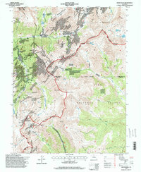
1994 Map of Montezuma
USGS Topo · Published 1998About this map
Montezuma sits at the heart of this high-elevation mining district, where the Snake River meets the confluence of glacial valleys. The landscape is defined by the Continental Divide and a dense network of late-century mining claims. Industrial heritage is preserved in labels for the Pennsylvania Mine, Saints John Mine, and the Star of the West Mine, reflecting a history of silver and base-metal extraction. Significant engineering features like the Roberts Tunnel pass beneath the peaks, while high-altitude routes like Webster Pass and the Argentine Trail provide access over the ridge lines between Arapaho National Forest and Pike National Forest. The convergence of Summit, Clear Creek, and Park counties atop the mountains underscores the complex administrative and geological boundaries of this central Colorado region.
Find a feature on this map
85 named features on this map. Tap any name to fly to it.
Don’t see what you’re looking for? This feature index may not catch every label — zoom into the map to look around manually.
Map Details
Editions of this 1994 Montezuma Map
This is the sole edition of this map. No revisions or reprints were ever made.
Other maps of this area

1903 · Georgetown
USGS Topo · 1:62,500

1905 · Georgetown
USGS Topo · 1:62,500

1924 · Montezuma
USGS Topo · 1:62,500

1926 · Montezuma
USGS Topo · 1:62,500

1933 · Montezuma
USGS Topo · 1:62,500

1937 · Como
USGS Topo · 1:62,500

1945 · Mount Logan
USGS Topo · 1:24,000

1948 · Mount Logan
USGS Topo · 1:24,000

1953 · Denver
USGS Topo · 1:250,000

1957 · Denver
USGS Topo · 1:250,000