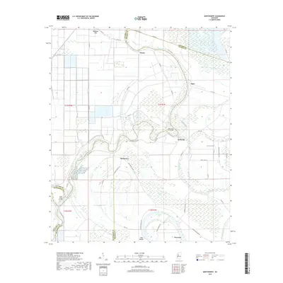
2018 Map of Montgomery
USGS Topo · Published 2018About this map
The Yazoo River dominates this landscape at the intersection of Leflore, Holmes, and Humphreys counties, carving a complex path of oxbows and cut-offs through the Mississippi Delta. The settlement of Morgan City sits in the northwest, while smaller communities like Mayday, Egypt, and Marksville are linked by a network of rural roads including Phillipston Rd and Egypt Rd. The hydrological history of the region is evident in features like Moon Lake, Horseshoe Lake, and Tehula Lake, remnants of the river's shifting course. Local history and genealogy interests are centered around Lennard Cem and family-named routes such as Baldwin Plantation Rd. The map also details significant water management features like the Yazoo River Levee Rd and the Silent Shade Cut-Off, illustrating the engineering required to manage the river's natural flood cycles in this productive agricultural region.
Find a feature on this map
57 named features on this map. Tap any name to fly to it.
Don’t see what you’re looking for? This feature index may not catch every label — zoom into the map to look around manually.
Map Details
Editions of this 2018 Montgomery Map
This is the sole edition of this map. No revisions or reprints were ever made.
Other maps of this area

1940 · Seven Pines
USGS Topo · 1:62,500

1940 · Lexington
USGS Topo · 1:62,500

1940 · Mileston
USGS Topo · 1:62,500

1953 · Greenwood
USGS Topo · 1:250,000

1954 · Mileston
USGS Topo · 1:62,500

1956 · Greenwood
USGS Topo · 1:250,000

1957 · Lexington
USGS Topo · 1:62,500

1957 · Seven Pines
USGS Topo · 1:62,500

1958 · Seven Pines
USGS Topo · 1:62,500

1958 · Lexington
USGS Topo · 1:62,500