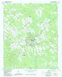
1972 Map of Monticello
USGS Topo · Published 1986About this map
The Jasper County seat of Monticello serves as the central hub for this mid-Georgia landscape, where the Central of Georgia railroad cuts a diagonal path through the terrain. The map reveals a community structured around civic and educational life, featuring the Piedmont Academy, a local Hospital, and several historic congregations such as Sardis Ch and Philadelphia Ch. To the south, the borders of the Oconee National Forest indicate a transition into protected timberlands, marked by the winding courses of Wise Creek and Lloyd Branch. Notable local landmarks like the Pope Country Club and a small Landing Strip suggest the town's mid-century expansion. Water management is evident through the inclusion of Sewage Disposal Ponds and a Tailings Pond, reflecting the infrastructure required for the growing settlements of Minnetta and Blackwell during the early 1970s and subsequent photorevisions.
Find a feature on this map
38 named features on this map. Tap any name to fly to it.
Don’t see what you’re looking for? This feature index may not catch every label — zoom into the map to look around manually.
Map Details
Editions of this 1972 Monticello Map
2 editions found
Other maps of this area

1951 · Forsyth
USGS Topo · 1:62,500

1953 · Athens
USGS Topo · 1:250,000

1958 · Athens
USGS Topo · 1:250,000

1959 · Athens
USGS Topo · 1:250,000

1963 · Athens
USGS Topo · 1:250,000

1964 · Lloyd Shoals Dam
USGS Topo · 1:24,000

1964 · Stewart
USGS Topo · 1:24,000

1964 · Stanfordville
USGS Topo · 1:24,000

1964 · Hillsboro
USGS Topo · 1:24,000

1972 · Monticello
USGS Topo · 1:24,000