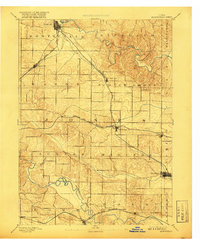
1891 Map of Monticello
USGS Topo · Published 1917About this map
Monticello anchors the northern edge of this Jones County landscape, where the Chicago Milwaukee and St Paul Railroad branches toward Longworthy and Scotch Grove. The terrain is defined by the winding courses of the Maquoketa River in the northeast and the Wapsipinicon River in the southwest, creating a complex series of ridges and valleys that shaped early settlement patterns.
Find a feature on this map
31 named features on this map. Tap any name to fly to it.
Don’t see what you’re looking for? This feature index may not catch every label — zoom into the map to look around manually.
Map Details
Editions of this 1891 Monticello Map
3 editions found
Other maps of this area

1889 · Tipton
USGS Topo · 1:62,500

1890 · Tipton
USGS Topo · 1:62,500

1890 · Anamosa
USGS Topo · 1:62,500

1891 · Monticello
USGS Topo · 1:62,500

1891 · Mechanicsville
USGS Topo · 1:62,500

1891 · Baldwin
USGS Topo · 1:62,500

1892 · Wheatland
USGS Topo · 1:62,500

1894 · Wheatland
USGS Topo · 1:62,500

1894 · Mechanicsville
USGS Topo · 1:62,500

1900 · Anamosa
USGS Topo · 1:125,000