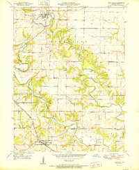
1951 Map of Monticello
USGS Topo · Published 1951About this map
The North Fabius River and its sister forks, the Middle Fabius River and Dickerson River, dominate this mid-century portrait of northeastern Missouri. This landscape is defined by the winding river valleys and the upland prairies of the Highland township, where the town of Monticello and the community of Ewing serve as primary centers. The map documents a rural infrastructure in transition, featuring numerous small cemeteries like Finley Cem and Garnett Cem, which are vital for genealogical research. Education in this era was still localized, as evidenced by Ten Mile Sch and Selton Sch, alongside the specifically noted Pleasant Hill Sch (Abandoned). The southern edge of the map is punctuated by the Chicago Burlington and Quincy railroad, which historically connected these agricultural communities to broader markets, while local landmarks such as Gilead Ch and various Quarry sites highlight the area's spiritual and industrial foundations.
Find a feature on this map
26 named features on this map. Tap any name to fly to it.
Don’t see what you’re looking for? This feature index may not catch every label — zoom into the map to look around manually.
Map Details
Editions of this 1951 Monticello Map
This is the sole edition of this map. No revisions or reprints were ever made.
Other maps of this area

1903 · Kahoka
USGS Topo · 1:125,000

1903 · Palmyra
USGS Topo · 1:125,000

1948 · Quincy
USGS Topo · 1:250,000

1949 · Durham
USGS Topo · 1:24,000

1949 · Maywood
USGS Topo · 1:24,000
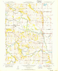
1950 · Maywood
USGS Topo · 1:24,000

1950 · Durham
USGS Topo · 1:24,000

1950 · La Grange
USGS Topo · 1:24,000

1950 · Benjamin
USGS Topo · 1:24,000

1950 · Williamstown
USGS Topo · 1:24,000