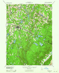
1943 Map of Monticello
USGS Topo · Published 1964About this map
Monticello serves as the central hub for this interior view of Sullivan County, situated at the junction of the Newburgh and Cochecton Road and New York 17. The landscape is defined by the early development of the Borscht Belt resort era, evidenced by the cluster of lakes and named settlements like South Fallsburgh and Kiamesha. To the south, the topography shifts toward the rugged Shawangunk Mts, where the New York Ontario and Western railroad winds through the hills near Haven.
Find a feature on this map
73 named features on this map. Tap any name to fly to it.
Don’t see what you’re looking for? This feature index may not catch every label — zoom into the map to look around manually.
Map Details
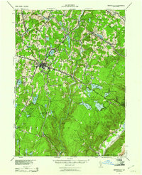
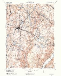
Editions of this 1943 Monticello Map
3 editions found
Other maps of this area

1903 · Slide Mountain
USGS Topo · 1:62,500

1904 · Ellenville
USGS Topo · 1:62,500

1905 · Slide Mountain
USGS Topo · 1:62,500

1906 · Ellenville
USGS Topo · 1:62,500

1906 · Port Jervis
USGS Topo · 1:62,500

1906 · Goshen
USGS Topo · 1:62,500

1908 · Goshen
USGS Topo · 1:62,500

1908 · Port Jervis
USGS Topo · 1:62,500

1909 · Monticello
USGS Topo · 1:62,500

1910 · Neversink
USGS Topo · 1:62,500