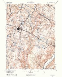
1943 Map of Monticello
USGS Topo · Published 1961About this map
Monticello serves as the focal point of this mid-century survey, situated at the intersection of the Newburgh and Cochecton Turnpike and the New York Ontario and Western RR. The landscape is characterized by a dense network of water bodies and summer retreats, including Merriewold Park and Mamakating Park, which highlight the region's development as a vacation destination. The presence of specialized stops like Hurleyville Luzon Sta and Merriewold St Josephs Sta reflects a period when rail travel was essential for accessing the hotels and clubs of the Catskills foothills. Beyond the larger settlements of South Fallsburgh and Mountaindale, the terrain is marked by significant hydrological features such as the Neversink River and the Shawangunk Mts, alongside numerous named reservoirs like Yankee Reservoir and Wolf Reservoir that point to the area's role in regional water management.
Find a feature on this map
67 named features on this map. Tap any name to fly to it.
Don’t see what you’re looking for? This feature index may not catch every label — zoom into the map to look around manually.
Map Details
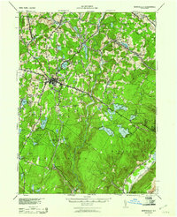
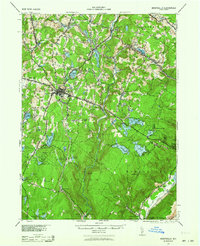
Editions of this 1943 Monticello Map
3 editions found
Other maps of this area

1903 · Slide Mountain
USGS Topo · 1:62,500

1904 · Ellenville
USGS Topo · 1:62,500

1905 · Slide Mountain
USGS Topo · 1:62,500

1906 · Ellenville
USGS Topo · 1:62,500

1906 · Port Jervis
USGS Topo · 1:62,500

1906 · Goshen
USGS Topo · 1:62,500

1908 · Goshen
USGS Topo · 1:62,500

1908 · Port Jervis
USGS Topo · 1:62,500

1909 · Monticello
USGS Topo · 1:62,500

1910 · Neversink
USGS Topo · 1:62,500