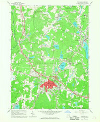
1966 Map of Monticello
USGS Topo · Published 1968About this map
Monticello serves as the focal point of this Sullivan County survey, showcasing the village's mid-century layout from the Courthouse and Hospital out toward the Monticello Raceway. The landscape reflects the era's booming resort and leisure economy, with extensive golf courses and the notable Kutshers Country Club situated near Anawana Lake. Higher education and public infrastructure are evident through the Sullivan County Community College and a series of regional water management sites like the Filtration Plant at Kiamesha Lake. Local history and genealogy are well-represented by several family and parish burial grounds, including Brookside Cem near Harris and the St Peters Cem on the village outskirts. Transportation patterns show a shift in the making, as the Old Railroad Grade north of Hurleyville marks the path of former rail lines replaced by a developing network of state routes and local thoroughfares like Reese Valley Road.
Find a feature on this map
52 named features on this map. Tap any name to fly to it.
Don’t see what you’re looking for? This feature index may not catch every label — zoom into the map to look around manually.
Map Details
Editions of this 1966 Monticello Map
3 editions found
Other maps of this area

1909 · Monticello
USGS Topo · 1:62,500

1910 · Neversink
USGS Topo · 1:62,500

1911 · Monticello
USGS Topo · 1:62,500

1921 · Livingston Manor
USGS Topo · 1:62,500

1922 · White Lake
USGS Topo · 1:62,500

1923 · Livingston Manor
USGS Topo · 1:62,500

1942 · White Lake
USGS Topo · 1:62,500

1942 · Neversink
USGS Topo · 1:62,500

1943 · White Lake
USGS Topo · 1:62,500

1943 · Monticello
USGS Topo · 1:62,500