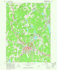
1966 Map of Monticello
USGS Topo · Published 1983About this map
Monticello serves as the focal point of this mid-1960s landscape, positioned as a regional hub of civic life and recreation within the Catskills. The village is anchored by its courthouse, hospital, and several schools including St Peters Sch and the Cooke Sch. To the northwest, the prominent Monticello Raceway highlights the area's significance as a destination for harness racing. The surrounding terrain is defined by a dense network of resort-era landmarks, from Kutshers Country Club near Anawana Lake to the expansion of Sullivan County Community College near South Fallsburg. This era also shows the remnants of earlier infrastructure, such as the Old Railroad Grade passing through Hurleyville, tracing the path of the former Ontario and Western Railway. Scattered throughout are local landmarks like the Brookside Cem and Rock Ridge Cem, which provide valuable touchstones for genealogical research in Thompson and Fallsburg.
Find a feature on this map
57 named features on this map. Tap any name to fly to it.
Don’t see what you’re looking for? This feature index may not catch every label — zoom into the map to look around manually.
Map Details
Editions of this 1966 Monticello Map
3 editions found
Other maps of this area

1909 · Monticello
USGS Topo · 1:62,500

1910 · Neversink
USGS Topo · 1:62,500

1911 · Monticello
USGS Topo · 1:62,500

1921 · Livingston Manor
USGS Topo · 1:62,500

1922 · White Lake
USGS Topo · 1:62,500

1923 · Livingston Manor
USGS Topo · 1:62,500

1942 · White Lake
USGS Topo · 1:62,500

1942 · Neversink
USGS Topo · 1:62,500

1943 · White Lake
USGS Topo · 1:62,500

1943 · Monticello
USGS Topo · 1:62,500