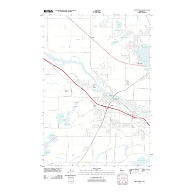
2010 Map of Monticello
USGS Topo · Published 2010About this map
The Mississippi River carves a diagonal path through this 2010 landscape, separating the developing suburban corridors of Monticello from the rural reaches of Sherburne and Wright counties. This era shows a significant expansion of transportation and aviation infrastructure, with three distinct private airstrips—Joyner Airport, Flynn Airport, and Pilots Cove Airport—clustered near the river’s southern bank. Local genealogy is well-preserved through several historic burial sites, including Saint Henrys Cemetery, Hillside Cemetery, and the riverside Riverside Cemetery. To the south, a chain of water bodies such as Bertram Lake, which features the Bertram Lake Dam, and Long Lake define the transition from town to open countryside. In the north, the small settlement of Salida sits near a dense network of lakes like Thompson Lake and Lake Mitchell, illustrating the region's enduring character as a destination for both residential growth and lakeside recreation.
Find a feature on this map
82 named features on this map. Tap any name to fly to it.
Don’t see what you’re looking for? This feature index may not catch every label — zoom into the map to look around manually.
Map Details
Editions of this 2010 Monticello Map
This is the sole edition of this map. No revisions or reprints were ever made.
Other maps of this area

1909 · Rockford
USGS Topo · 1:62,500

1953 · Stillwater
USGS Topo · 1:250,000

1955 · Stillwater
USGS Topo · 1:250,000

1958 · Stillwater
USGS Topo · 1:250,000

1958 · Rockford
USGS Topo · 1:62,500

1958 · Buffalo
USGS Topo · 1:62,500

1961 · Clear Lake
USGS Topo · 1:24,000

1961 · Big Lake
USGS Topo · 1:24,000

1961 · Silver Creek
USGS Topo · 1:24,000

1961 · Orrock
USGS Topo · 1:24,000