
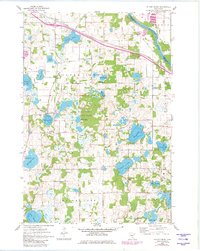
1961 Map of Silver Creek
USGS Topo · Published 1963About this map
The Mississippi River forms the northeastern boundary of this Wright County landscape, where the Great Northern railroad cuts through the small settlements of Hasty and Enfield. This 1961 field-checked survey reveals a territory defined by its glacial lakes, from the broad waters of Ida Lake and Maria Lake to the smaller Locke Lake and Silver Lake. The map documents the community hubs of the early 1960s, including the Silver Creek Ch and the Carter Sch.
Find a feature on this map
31 named features on this map. Tap any name to fly to it.
Don’t see what you’re looking for? This feature index may not catch every label — zoom into the map to look around manually.
Map Details
Editions of this 1961 Silver Creek Map
2 editions found
Other maps of this area

1951 · Annandale
USGS Topo · 1:62,500

1953 · Saint Cloud
USGS Topo · 1:250,000

1953 · Stillwater
USGS Topo · 1:250,000

1955 · Stillwater
USGS Topo · 1:250,000

1957 · Saint Cloud
USGS Topo · 1:250,000

1958 · Stillwater
USGS Topo · 1:250,000

1958 · Saint Cloud
USGS Topo · 1:250,000

1958 · Buffalo
USGS Topo · 1:62,500

1958 · Cokato
USGS Topo · 1:62,500

1961 · Clear Lake
USGS Topo · 1:24,000