
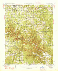
1948 Map of Montier
USGS Topo · Published 1948About this map
The ST Louis-San Francisco railroad cuts across the northern landscape of this Missouri Ozarks survey, anchoring the timber-and-rail economy of Mountain View, Teresita, and Montier. The terrain is defined by a dense network of country schools and churches that served these isolated communities shortly after World War II. Local education centers like Shady Grove Sch and Congo Sch appear alongside rural spiritual landmarks such as New Salem Ch and Mt Calvary Ch.
Find a feature on this map
60 named features on this map. Tap any name to fly to it.
Don’t see what you’re looking for? This feature index may not catch every label — zoom into the map to look around manually.
Map Details
Editions of this 1948 Montier Map
2 editions found
Other maps of this area

1915 · Eminence
USGS Topo · 1:62,500

1917 · Eminence
USGS Topo · 1:62,500

1931 · Bandyville
USGS Topo · 1:48,000

1938 · West Plains
USGS Topo · 1:24,000

1940 · West Plains
USGS Topo · 1:24,000

1943 · Thayer
USGS Topo · 1:62,500

1944 · West Plains
USGS Topo · 1:62,500

1944 · Couch
USGS Topo · 1:62,500

1944 · Birch Tree
USGS Topo · 1:62,500

1945 · Willow Springs
USGS Topo · 1:62,500