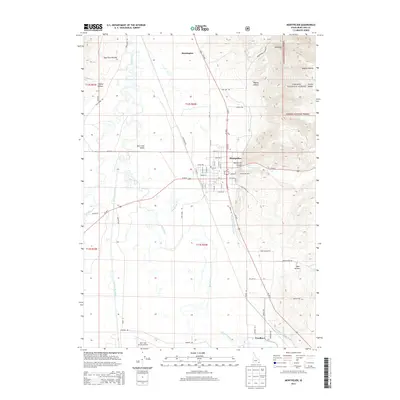
2013 Map of Montpelier
USGS Topo · Published 2013About this map
Bear Lake Valley serves as the central hub for this corner of Southeast Idaho, where the Bear River winds through a landscape defined by its irrigation and transportation networks. The city of Montpelier is the primary population center, positioned where Montpelier Cr emerges from Montpelier Canyon. To the north and south, the smaller settlements of Bennington and Wardboro anchor the agricultural corridor. The valley floor is crisscrossed by vital water works like the Montpelier Preston Canal and the Kent La Rocco Canal, which support the region's ranching and farming heritage.
Find a feature on this map
54 named features on this map. Tap any name to fly to it.
Don’t see what you’re looking for? This feature index may not catch every label — zoom into the map to look around manually.
Map Details
Editions of this 2013 Montpelier Map
This is the sole edition of this map. No revisions or reprints were ever made.
Other maps of this area

1909 · Montpelier
USGS Topo · 1:125,000

1911 · Montpelier
USGS Topo · 1:125,000

1955 · Preston
USGS Topo · 1:250,000

1958 · Preston
USGS Topo · 1:250,000

1962 · Preston
USGS Topo · 1:250,000

1967 · Montpelier
USGS Topo · 1:24,000

1967 · Paris
USGS Topo · 1:24,000

1967 · Ovid
USGS Topo · 1:24,000

1967 · Dingle
USGS Topo · 1:24,000
1970 · Georgetown
USGS Topo · 1:24,000