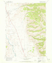
1970 Map of Georgetown
USGS Topo · Published 1973About this map
Bear Lake Valley serves as a corridor for settlement and industry in this early 1970s survey, dominated by the winding course of the Bear River. The agricultural and ranching character of the region is evident through the presence of numerous Gravel Pits, Borrow Pits, and Storage Bins scattered near the Union Pacific railroad line. Small communities like Georgetown and Bennington anchor the valley floor, while a network of pipelines and irrigation features like the Gaging Station indicate the intensive management of local water resources.
Find a feature on this map
42 named features on this map. Tap any name to fly to it.
Don’t see what you’re looking for? This feature index may not catch every label — zoom into the map to look around manually.
Map Details
Editions of this 1970 Georgetown Map
2 editions found
Other maps of this area

1909 · Montpelier
USGS Topo · 1:125,000

1911 · Montpelier
USGS Topo · 1:125,000

1911 · Slug Creek
USGS Topo · 1:62,500

1915 · Crow Creek
USGS Topo · 1:62,500

1949 · Snowdrift Mountain
USGS Topo · 1:24,000
1951 · Snowdrift Mountain
USGS Topo · 1:24,000

1955 · Preston
USGS Topo · 1:250,000

1958 · Preston
USGS Topo · 1:250,000

1962 · Preston
USGS Topo · 1:250,000

1967 · Montpelier
USGS Topo · 1:24,000