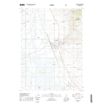
2020 Map of Montpelier
USGS Topo · Published 2020About this map
Montpelier serves as the central hub for the Bear Lake Valley in this southeastern Idaho survey, positioned where the valley floor meets the rising peaks of the Preuss Range. The town’s grid is clearly defined, with streets like Washington St and Adams St leading toward the opening of Montpelier Canyon. To the west and south, the landscape is defined by the complex hydrology of the Bear River and the Bear Lake Outlet, which weave through a series of marshes and wetlands. This area represents a critical junction of agricultural land and protected wilderness, with the Caribou National Forest beginning its ascent just east of the settlement. Further south, the community of Wardboro and the Bear Lake County Airport highlight the infrastructure supporting this corner of the state. Topographical features such as Red Pine Hollow and Joes Gap indicate the transition from the flat, river-fed basin to the surrounding highlands.
Find a feature on this map
51 named features on this map. Tap any name to fly to it.
Don’t see what you’re looking for? This feature index may not catch every label — zoom into the map to look around manually.
Map Details
Editions of this 2020 Montpelier Map
This is the sole edition of this map. No revisions or reprints were ever made.
Other maps of this area

1909 · Montpelier
USGS Topo · 1:125,000

1911 · Montpelier
USGS Topo · 1:125,000

1955 · Preston
USGS Topo · 1:250,000

1958 · Preston
USGS Topo · 1:250,000

1962 · Preston
USGS Topo · 1:250,000

1967 · Montpelier
USGS Topo · 1:24,000

1967 · Paris
USGS Topo · 1:24,000

1967 · Ovid
USGS Topo · 1:24,000

1967 · Dingle
USGS Topo · 1:24,000
1970 · Georgetown
USGS Topo · 1:24,000