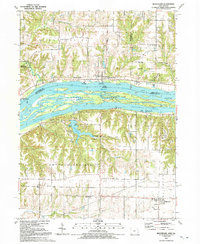
1991 Map of Montpelier
USGS Topo · Published 1992About this map
Andalusia Island dominates the center of this map, dividing the waters of the Mississippi River into the main channel and the southern Andalusia Slough. Along the Iowa banks, the town of Montpelier and the riverside community of Midway Beach sit just upstream from Wildcat Den State Park, illustrating the blend of residential and recreational land use in Muscatine County. Across the river in Illinois, the landscape shifts toward the high bluffs of Buffalo Prairie, where the settlement of Edgington serves as a local hub near St Patricks Ch.
Find a feature on this map
33 named features on this map. Tap any name to fly to it.
Don’t see what you’re looking for? This feature index may not catch every label — zoom into the map to look around manually.
Map Details
Editions of this 1991 Montpelier Map
This is the sole edition of this map. No revisions or reprints were ever made.
Other maps of this area

1890 · Durant
USGS Topo · 1:62,500

1891 · Davenport
USGS Topo · 1:62,500

1894 · Durant
USGS Topo · 1:62,500

1894 · Davenport
USGS Topo · 1:62,500

1901 · Rock Island
USGS Topo · 1:125,000

1910 · Rock Island
USGS Topo · 1:125,000

1912 · Milan
USGS Topo · 1:62,500

1916 · Edgington
USGS Topo · 1:62,500

1938 · Edgington
USGS Topo · 1:62,500

1944 · Milan
USGS Topo · 1:62,500