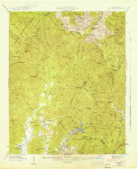
1943 Map of Montreat
USGS Topo · Published 1943About this map
Montreat and its neighboring valley communities are defined by the convergence of steep peaks and high-altitude watersheds in the Black Mountains. This 1943 survey, conducted by the Tennessee Valley Authority and the Geological Survey, reveals a landscape of religious and educational retreat, anchored by Lake Susan and the nearby Black Mtn College at Lake Eden. The complex drainage patterns of the North Fork Swannanoa River and South Fork Swannanoa River dictate the settlement pattern, which is concentrated along the lower elevations while the high ridges are reserved for the Asheville Watershed and the Pisgah National Forest.
Find a feature on this map
95 named features on this map. Tap any name to fly to it.
Don’t see what you’re looking for? This feature index may not catch every label — zoom into the map to look around manually.
Map Details
Editions of this 1943 Montreat Map
2 editions found
Other maps of this area

1900 · Mount Mitchell
USGS Topo · 1:125,000

1902 · Mount Mitchell
USGS Topo · 1:125,000

1934 · Parts Of Celo And Black Brothers
USGS Topo · 1:24,000

1934 · Parts Of Old Fort and Montreat
USGS Topo · 1:24,000

1935 · Montreat
USGS Topo · 1:24,000

1935 · Black Brothers
USGS Topo · 1:24,000

1935 · Black Mountain
USGS Topo · 1:24,000

1935 · Barnardsville
USGS Topo · 1:24,000

1935 · Craggy Pinnacle
USGS Topo · 1:24,000

1941 · Black Mountain
USGS Topo · 1:24,000