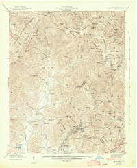
1943 Map of Montreat
USGS Topo · Published 1943About this map
Montreat and its centerpiece Lake Susan occupy a steep mountain valley during the early 1940s, serving as a hub of retreat and education. To the southwest, Black Mtn College and Lake Eden appear at a significant moment in the college's history, while the surrounding Pisgah National Forest and Asheville Watershed dominate the high ridges of the Craggy Mountains. The terrain is characterized by the Tennessee Valley Divide, where the North Fork Swannanoa River begins its descent through narrow coves like Buckeye Cove.
Find a feature on this map
117 named features on this map. Tap any name to fly to it.
Don’t see what you’re looking for? This feature index may not catch every label — zoom into the map to look around manually.
Map Details
Editions of this 1943 Montreat Map
2 editions found
Other maps of this area

1900 · Mount Mitchell
USGS Topo · 1:125,000

1902 · Mount Mitchell
USGS Topo · 1:125,000

1934 · Parts Of Celo And Black Brothers
USGS Topo · 1:24,000

1934 · Parts Of Old Fort and Montreat
USGS Topo · 1:24,000

1935 · Montreat
USGS Topo · 1:24,000

1935 · Black Brothers
USGS Topo · 1:24,000

1935 · Black Mountain
USGS Topo · 1:24,000

1935 · Barnardsville
USGS Topo · 1:24,000

1935 · Craggy Pinnacle
USGS Topo · 1:24,000

1941 · Black Mountain
USGS Topo · 1:24,000