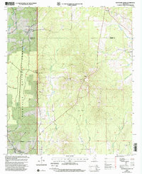
2000 Map of Montrose North
USGS Topo · Published 2002About this map
The Bienville National Forest dominates the western portion of this landscape, where the Newton Co Jasper Co line divides the dense woodlands from the eastern rural holdings. This 2000 revision highlights a complex network of headwaters including Tallahoma Creek, Scotchenflipper Creek, and Souenlouie Creek, which drain the undulating terrain. The human footprint is defined by a series of long-standing community centers and family landmarks, with Garlandville and Montrose anchoring the corners of the sheet. The interior is characterized by significant genealogical sites like Pilgrim Rest Cems and Pleasant Hill Cem, alongside rural spiritual centers such as Sand Ridge Ch and Oak Grove Ch. Industrial and utility infrastructure is also evident through the prominent Pipeline corridor and the Baxter Lookout Tower situated near the small settlement of Baxter.
Find a feature on this map
25 named features on this map. Tap any name to fly to it.
Don’t see what you’re looking for? This feature index may not catch every label — zoom into the map to look around manually.
Map Details
Editions of this 2000 Montrose North Map
This is the sole edition of this map. No revisions or reprints were ever made.
Other maps of this area

1921 · Forest
USGS Topo · 1:48,000

1922 · Forest
USGS Topo · 1:62,500

1950 · Forest
USGS Topo · 1:62,500

1952 · Forest
USGS Topo · 1:62,500

1953 · Meridian
USGS Topo · 1:250,000

1957 · Meridian
USGS Topo · 1:250,000

1965 · Meridian
USGS Topo · 1:250,000

1966 · Hickory
USGS Topo · 1:24,000

1966 · Newton
USGS Topo · 1:24,000

1968 · Clear Springs
USGS Topo · 1:24,000