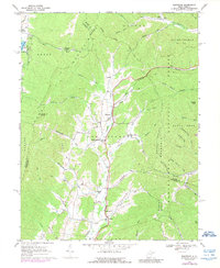
1969 Map of Montrose
USGS Topo · Published 1989About this map
Leading Creek carves a central valley through this West Virginia landscape, providing a corridor for both the Western Maryland RR and U.S. Route 219. The town of Montrose serves as a primary hub along this transit line, flanked by smaller communities like Smith Crossing and Kerens. To the east, the terrain rises sharply into Pheasant Mountain within the bounds of the Monongahela National Forest, where numerous runs like Haddix Run and Pleasant Run drain the high ridges.
Find a feature on this map
66 named features on this map. Tap any name to fly to it.
Don’t see what you’re looking for? This feature index may not catch every label — zoom into the map to look around manually.
Map Details
Editions of this 1969 Montrose Map
3 editions found
Other maps of this area

1886 · St. George
USGS Topo · 1:125,000

1889 · Beverly
USGS Topo · 1:125,000

1891 · St. George
USGS Topo · 1:125,000

1892 · Beverly
USGS Topo · 1:125,000

1907 · Belington
USGS Topo · 1:62,500

1908 · Parsons
USGS Topo · 1:62,500

1909 · Elkins
USGS Topo · 1:62,500

1922 · Horton
USGS Topo · 1:48,000

1924 · Horton
USGS Topo · 1:62,500

1926 · Parsons
USGS Topo · 1:62,500