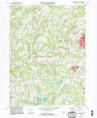
1994 Map of Montrose West
USGS Topo · Published 1995About this map
Montrose serves as the focal point for this Susquehanna County region, featuring essential civic structures including the Courthouse, Po, and Library. The surrounding landscape is characterized by a high concentration of Quarry sites and Quarries, illustrating the local reliance on stone extraction. Small rural settlements like Fairdale, Bumps Corners, and Snows Mill are connected by a network of winding valley roads and creeks.
Find a feature on this map
51 named features on this map. Tap any name to fly to it.
Don’t see what you’re looking for? This feature index may not catch every label — zoom into the map to look around manually.
Map Details
Editions of this 1994 Montrose West Map
2 editions found
Other maps of this area

1943 · Montrose
USGS Topo · 1:62,500

1943 · Le Raysville
USGS Topo · 1:62,500

1945 · Montrose
USGS Topo · 1:62,500

1945 · Le Raysville
USGS Topo · 1:62,500

1945 · Meshoppen
USGS Topo · 1:62,500

1945 · Auburn Center
USGS Topo · 1:24,000

1946 · Tunkhannock
USGS Topo · 1:62,500

1946 · Springville
USGS Topo · 1:24,000

1946 · Hop Bottom
USGS Topo · 1:24,000

1947 · Hopbottom
USGS Topo · 1:24,000