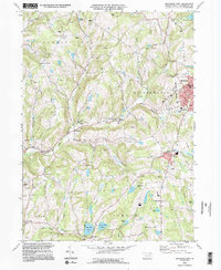
1994 Map of Montrose West
USGS Topo · Published 1995About this map
The Susquehanna County seat of Montrose anchors the eastern edge of this landscape, where the Courthouse, Library, and Holy Name of Mary Ch serve as local landmarks. The surrounding terrain is defined by the winding course of Wyalusing Creek and its branches, cutting through high ridges like North Hill and Louden Hill. Numerous quarries are scattered across Bridgewater, Jessup, and Dimock townships, reflecting the region's long-standing stone industry.
Find a feature on this map
51 named features on this map. Tap any name to fly to it.
Don’t see what you’re looking for? This feature index may not catch every label — zoom into the map to look around manually.
Map Details
Editions of this 1994 Montrose West Map
2 editions found
Other maps of this area

1943 · Montrose
USGS Topo · 1:62,500

1943 · Le Raysville
USGS Topo · 1:62,500

1945 · Montrose
USGS Topo · 1:62,500

1945 · Le Raysville
USGS Topo · 1:62,500

1945 · Meshoppen
USGS Topo · 1:62,500

1945 · Auburn Center
USGS Topo · 1:24,000

1946 · Tunkhannock
USGS Topo · 1:62,500

1946 · Springville
USGS Topo · 1:24,000

1946 · Hop Bottom
USGS Topo · 1:24,000

1947 · Hopbottom
USGS Topo · 1:24,000