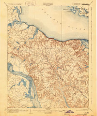
1892 Map of Montross
USGS Topo · Published 1930About this map
The Northern Neck of Virginia in the late nineteenth century is defined here by its complex relationship with the waters of the Potomac River and the Rappahannock River. Topographer A. E. Murlin recorded a landscape where maritime transport was the primary economic engine, evidenced by the numerous landings and wharves such as Massey Wharf, Wirt Wharf, and Smith Mount Ldg. that serviced the local population. The interior is a labyrinth of deep ravines and ridges leading to the courthouse town of Montross, while the riverfront is dotted with named points and inlets including Currioman Bay and the historic Stratford estate area.
Find a feature on this map
58 named features on this map. Tap any name to fly to it.
Don’t see what you’re looking for? This feature index may not catch every label — zoom into the map to look around manually.
Map Details
Editions of this 1892 Montross Map
5 editions found
Other maps of this area

1889 · Fredericksburg
USGS Topo · 1:125,000

1892 · Leonardtown
USGS Topo · 1:62,500

1892 · Fredericksburg
USGS Topo · 1:125,000

1892 · Piney Point
USGS Topo · 1:62,500

1892 · Montross
USGS Topo · 1:62,500

1894 · Wicomico
USGS Topo · 1:62,500

1894 · Fredericksburg
USGS Topo · 1:125,000

1894 · Piney Point
USGS Topo · 1:62,500

1895 · Wicomico
USGS Topo · 1:62,500

1895 · Leonardtown
USGS Topo · 1:62,500